Using Satellite Imagery to Analyze Border Conflicts
Explore how satellite imagery is used to analyze border conflicts, providing insights into military activity, infrastructure changes, and population displacement.
Using Satellite Imagery to Analyze Border Conflicts
Using Satellite Imagery to Analyze Border Conflicts
Border conflicts are a persistent feature of the international landscape, often resulting in significant human and economic costs. Traditional methods of monitoring and analyzing these conflicts can be limited by access, political constraints, and the difficulty of obtaining timely and accurate information. Satellite imagery offers a powerful and increasingly accessible tool for overcoming these limitations, providing objective, comprehensive, and up-to-date insights into border regions.
The Power of Satellite Imagery
Satellite imagery captures visual data of the Earth's surface from space. This data can be used to monitor changes in land use, infrastructure development, population displacement, and military activity. Unlike traditional ground-based methods, satellite imagery provides a bird's-eye view of entire border regions, offering a synoptic perspective that can reveal patterns and trends that might otherwise go unnoticed.
Key Applications of Satellite Imagery in Border Conflict Analysis:
- Monitoring Military Activity: Satellite imagery can detect the presence and movement of troops, vehicles, and equipment, providing early warning of potential escalations.
- Assessing Infrastructure Development: New roads, bridges, and settlements in border areas can be indicators of changing territorial control or strategic intentions.
- Tracking Population Displacement: Satellite imagery can identify refugee camps and informal settlements, providing insights into the human impact of border conflicts.
- Detecting Environmental Damage: Conflicts can lead to deforestation, pollution, and other forms of environmental damage that can be monitored using satellite imagery.
- Verifying Agreements: Satellite imagery can be used to verify compliance with ceasefire agreements and other border-related treaties.
Types of Satellite Imagery
Several types of satellite imagery are available, each with its own strengths and limitations:
- Optical Imagery: Captures images using visible and near-infrared light, similar to a conventional camera. Offers high resolution and detailed visual information but is affected by cloud cover.
- Radar Imagery: Uses radio waves to penetrate clouds and darkness, providing data even in adverse weather conditions. Useful for monitoring areas with frequent cloud cover.
- Thermal Imagery: Measures the heat emitted by objects on the Earth's surface. Can be used to detect fires, industrial activity, and other thermal anomalies.
Case Studies
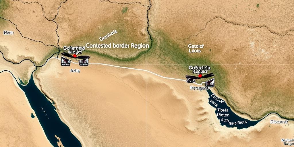
- The India-Pakistan Border: Satellite imagery has been used to monitor troop deployments, infrastructure development, and ceasefire violations along the Line of Control.
- The Israel-Palestine Border: Satellite imagery has been used to track settlement expansion, monitor the construction of the separation barrier, and assess the impact of conflict on agricultural land.
- The Armenia-Azerbaijan Border: Satellite imagery played a crucial role in monitoring military movements and assessing damage during the 2020 Nagorno-Karabakh conflict.
Challenges and Limitations
While satellite imagery offers a powerful tool for border conflict analysis, it is important to be aware of its limitations:
- Cost: High-resolution satellite imagery can be expensive, limiting its accessibility for some researchers and organizations.
- Technical Expertise: Analyzing satellite imagery requires specialized skills and software.
- Interpretation: The interpretation of satellite imagery can be subjective, and different analysts may draw different conclusions.
- Data Availability: Access to satellite imagery may be restricted in some areas due to security concerns or political sensitivities.
Conclusion
Satellite imagery is transforming the way we understand and analyze border conflicts. By providing timely, objective, and comprehensive information, it can help policymakers, researchers, and humanitarian organizations make more informed decisions and respond more effectively to these complex and challenging situations. As satellite technology continues to advance and data becomes more accessible, the role of satellite imagery in border conflict analysis is likely to grow even further.